
I’m a late GPS adopter; I first started using one on my bike about five years ago, when I was planning a ride from Fort Collins, Colorado, to the Overland Expo outside Flagstaff, Arizona. I still like to carry paper maps, but it’s nice to be able to glance down and see where you are, and in unfamiliar towns I like having the voice in my helmet telling me where to turn, allowing me to give the surroundings my full attention.
When I heard about Garmin’s new 595LM model, my interest was piqued, mostly because of one feature in particular: Garmin Adventurous Routing, which calculates routes that include curves and hills, and avoid major highways. The user can adjust the “intensity” of the adventure using a sliding scale with three settings for each feature: all the way to the left (fewer hills and curves and more major highways), the middle and all the way to the right (more hills and curves and fewer major highways). More on that in a moment.
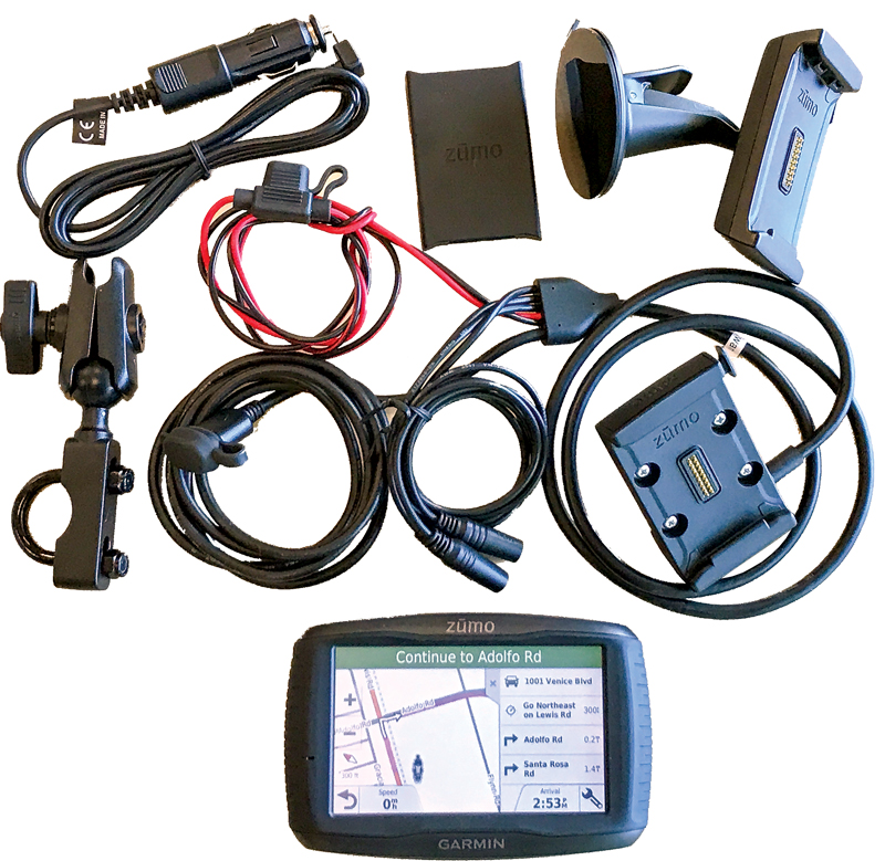
The 595LM is fairly straightforward to install, with the most difficult part being routing all the cables—in addition to power, there are three mic/line-in/line-out jacks plus a USB—under the gas tank and/or fairings. It comes with a U-shaped bracket that mounts on most handlebars, as well as a suction cup and 12V cigarette lighter adapter for use in a car.
In order to use the 595LM, you start by plugging the unit into your computer with the included USB cable, and it walks you through the steps from there: installing the (free) Garmin Express software, updating the map on the GPS—the “LM” in 595LM stands for Lifetime Maps, meaning you’ll get free map upgrades for life—and getting started with the user manual.
At this point, you can head out and start riding. The 595LM is equipped with a host of useful features, most of which are customizable, such as alerts for things like school zones, red light cameras and upcoming curves, locations of interest like restaurants and gas stations, and functions that allow you to avoid toll roads, certain road features and even entire areas—useful if you’re riding through a major city but you don’t want to go right through the middle of town.
Then there’s the aforementioned Adventurous Routing. I decided to test it out by entering a destination in Venice, California, which is southeast of our Camarillo office on the other side of the Santa Monica Mountains. I know that there are several ways to get to Venice: the freeway, the coast highway or through the mountains. So I dialed the sliders all the way to the right—the most adventurous routing. Little did I know…. After calculating for about 30 seconds, the Garmin offered up a route to my destination, roughly an hour away via the quickest route, that was 32 hours long! It took me inland, north through Yosemite National Park, south past Las Vegas and through Death Valley before approaching Venice from the east.
OK Garmin, you’re right, that is quite the adventurous route! And it did hit several amazing roads—but I was looking for something just a little faster. So I dialed back the sliders to the middle, and it offered me a nice hour-and-a-half-long route through the mountains. It should be noted that you can change your route at any time by simply touching a road on the map and selecting it as a waypoint; the 595LM recalculates quickly.
In order to take full advantage of the 595LM’s capabilities, you should also pair it to your smartphone and Bluetooth helmet headset. Pairing it to your phone not only allows you to get phone notifications and pick up calls directly on the GPS, it also allows you to get real-time traffic and weather data and stream Pandora, Spotify or music stored on your phone. The learning curve for using the 595LM is easier if you’ve used a Garmin zumo GPS before, but it’s intuitive enough for a first-timer to master quickly. The 5-inch touchscreen works very well with gloves on, and most of the buttons are large. It’s bright enough to see in all but the most direct glaring sunlight, easily remedied by angling the unit up or down. Garmin also offers compatible accessories, such as a tire pressure monitoring system and the VIRB action camera.
If you don’t mind a smaller screen and don’t need the music streaming capability, you can save a few hundred bucks (and some installation frustration) and get the 4.3-inch zumo 395LM ($499.99). But as a full-featured motorcycle-specific GPS, the zumo 595LM ($799.99) is the top-of-the-line choice.
For more information, call (888) 442-7646 or visit garmin.com.


I’d like to offer my personal experience with the Garmin Zumo GPS units (in my case, the 395LM which works the same as the 595 you reviewed). I would urge ANY rider, but especially women riders travelling alone, to be very careful with that adventurous routing. Mine has numerous times routed me onto roads I did not want to be on and some were in fact dangerous – by that I mean gravel roads, dirt/mud roads, and one-lane wide roads with no shoulder pull off if a vehicle comes from the opposite way (nothing like a one-lane road with numerous totally blind curves to get your attention). And yes, it has taken me on gravel and dirt roads despite the fact that I set the device to avoid such roads! One routing took me through a one-lane gravel, dirt and mud “road” through a wetlands swamp in Virginia, and once it took me and my ladyfriend passenger over a 6-foot wide paved “trail” through the woods. You want to keep that “curvy road” slider full left or MAYBE in the middle (it hasstill bit me many times when set in the middle).
Another thing that will bite you is the hill setting – unless you are going off-road and like hills a lot leave that set full left because it will route you on some stupid or dangerous roads just because there is a hill there (later experimentation showed me that the one-lane paved trail through the woods I mentioned above was because of the hill slider being set in the middle). It seems to defer to hills first even if it isn’t set to off-road.
I’ll also add that the ability to create custom routes in Garmin’s BaseCamp software and download the route to these GPS units sounds fantastic, but in my experience it has been a disaster. You can spend hours creating a route in BaseCamp and then, when you load it into the unit, the unit recalculates the route! Which wouldn’t matter except and the GPS and the BaseCamp software apparently use totally different algorithms to do their calculations so the routes will not match! In 26 rides this year the GPS has followed my route somewhat closely only two times – the rest were not even close. And Garmin’s “documentation” (some online video’s) is worthless. As much as I want to love the Garmin all I can say is it leaves much to be desired. It’s better than paper maps for getting directions on the fly, but that’s about it.