
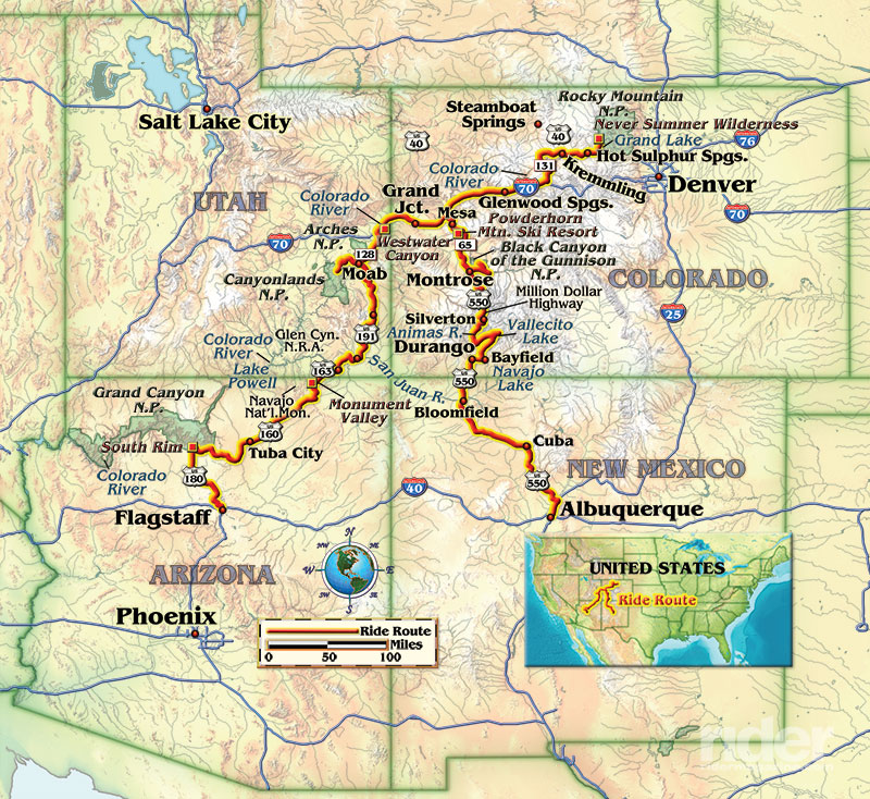
Having just retired from a wildfire management position with the Forest Service the previous year, and thus off the hook for working fire pre-suppression all summer long, I took the opportunity to ride up into the high Rockies in June, following the great rivers—the Colorado and its tributaries—all the way to their origin. Departing from Albuquerque, New Mexico, I rode west over the Continental Divide near Cuba and headed toward Colorado. The first river I crossed was the San Juan. Emerging from Navajo Lake, the San Juan surged, swollen and powerful, as it flowed through Bloomfield, New Mexico. It would gather a lot more momentum and volume before I saw it again a few days later.
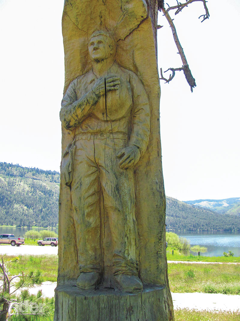
Near Bayfield, Colorado, I rode a few miles up County Road 501 to reach Vallecito Lake, a reservoir on the Los Pinos River. The backdrop for the high-altitude lake was a hillside of charred snags, evidence of the 70,000-acre Missionary Ridge Fire of 2002. It caused the evacuations of several subdivisions in the lakeside community of Vallecito, and 83 structures burned. Sadly, a falling tree killed a contract sawyer working on the fire, which led to stronger safety guidelines for all federal contractors.
County Road 240 curves under the tall, cool pines to reach Durango. Beneath the bridge on U.S. Route 550, the Animas River thundered past, waves standing up and whitewater boiling. Just downstream, kayakers were lined up to run the wild river. Its Class V rapids only last a couple weeks each year before it returns to a placid, clear, cold stream draining the San Juan Mountains.
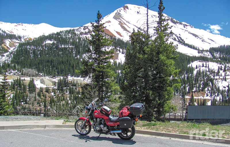
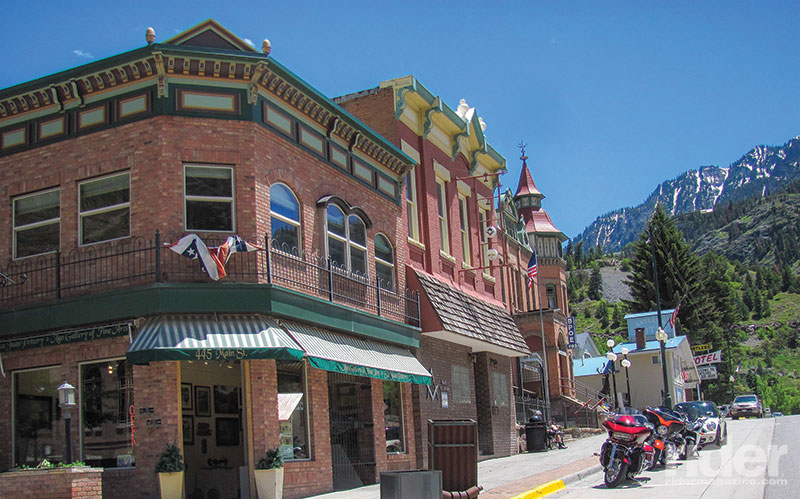
One of the Top 10 rides on anyone’s list of superlative routes, U.S. 550, a.k.a the “Million Dollar Highway,” north of Durango, includes three high-altitude passes, one topping out at more than 11,000 feet. Under a severe, clear sky in chilly temperatures, I rode past snow patches piled in the shade. Still, a hundred motorcycles of all types shared the roadway with me.
I camped for the night at Black Canyon of the Gunnison National Park, an off-the-beaten-path destination preserving the deep gash that is the Gunnison River Canyon. At the campfire talk that evening, the ranger told a small crowd that the 8,200-foot-high rim of the canyon boasts some of the highest altitude piñon pine and juniper trees in the world, along with a menagerie of forest animals including bobcats, mountain lions, porcupines, mule deer, chipmunks, owls and hawks. Intimidated by the thin air at this high elevation, I rode down to the bottom of the canyon to complete my morning run at a “mere” 6,500 feet. My jog up to the dam and back was scenic and delightful along the banks of the Gunnison River, on its rushing way to meet the Colorado.
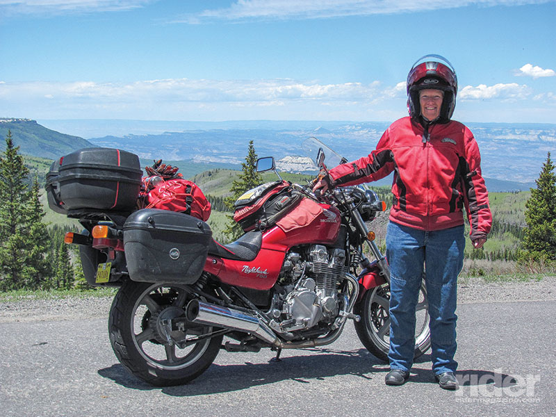
Detouring away from the Gunnison for the time being, next I headed toward the Grand Mesa Scenic and Historic Byway along State Highway 65. The top of the mesa, at more than 10,000 feet, affords a spectacular view of the Book Cliffs across the valley to the north. The long, winding road descending from the north side of the mesa passes the Powderhorn Mountain Ski Resort before picking up Plateau Creek. Ten miles of delightfully deserted curves lead down to Interstate 70.
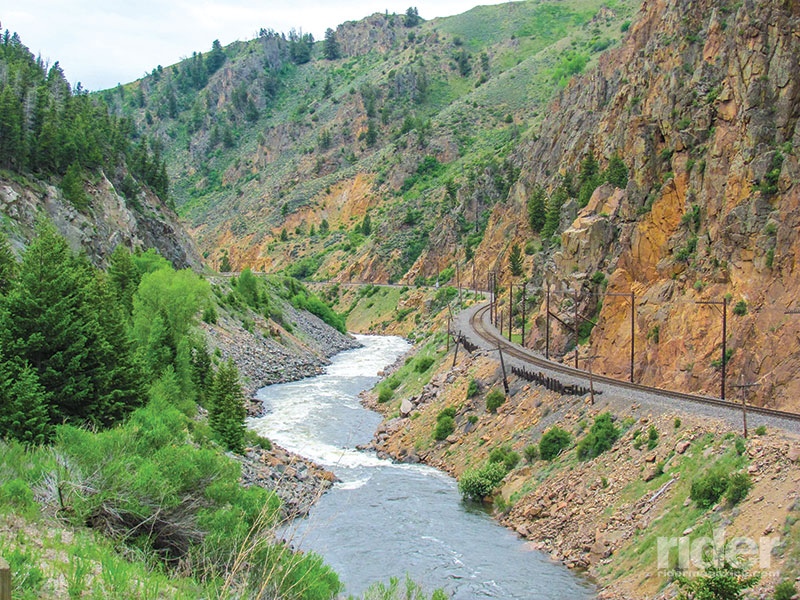
One of the few Interstates actually marked as a Scenic Route on maps, I-70 follows the Colorado River as it cuts directly across the middle of the state. I turned east, passing desert cliffs that gradually turned into green-cloaked mountains as I gained elevation. When I reached Glenwood, I found a campground located beneath Storm King Mountain. I shivered with trepidation, as the significance of this destination was etched on my consciousness.
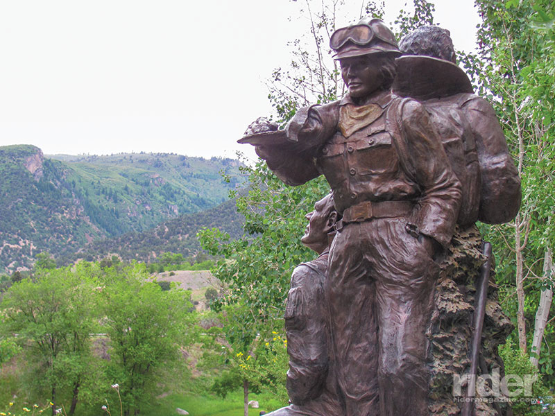
I was working as a helicopter “helitack” crewmember in Alaska when an incident occurred on Storm King Mountain in July 1994 that rocked the wildland fire community. Some 80 firefighters had converged to fight a lightning-caused fire on the mountaintop. Without warning, a cold front passed over them in the afternoon and whipped the brush fire into a firestorm. The firefighters working the west flank of the fire were caught by the blow-up and ran for their lives. Fourteen didn’t make it.
In the wake of the disaster, the Forest Service conducted exhaustive investigations, which resulted in many safety and leadership issues being addressed for the first time. The Storm King tragedy changed a lot of things about the way we fight fire, including clearer identification of who’s in charge, redefinition of escape routes and better weather information dissemination.
Twenty-one years later, the mountaintop was still spiked with blackened snags. I rode down to Two Rivers Park in downtown Glenwood Springs, a peaceful place where the Roaring Fork River splashes down from Aspen to empty into the Colorado. With a lump in my throat, I walked around the memorial created for the “Storm King 14,” and said a prayer for them.
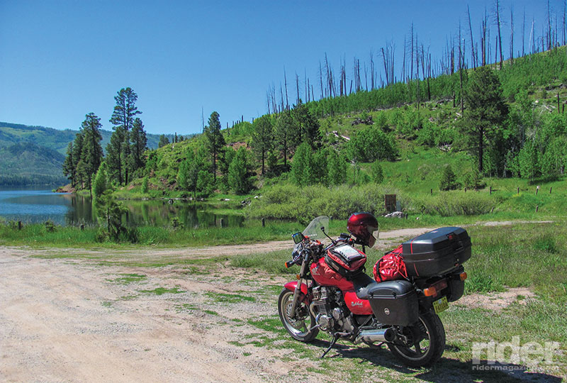
Fifty miles east of Glenwood, I rode onto another scenic byway that leads up toward the headwaters of the Colorado River. State Highway 131 runs alongside the water for a while until State Highway 134 cuts off to the east toward Gore Pass. On the other side, it meets a smaller but still overfull Colorado, through the high plains-like little town of Kremmling. Beyond there the river tears through a steep canyon. The road runs next to it into Hot Sulphur Springs, then beyond that a few miles to Grand Lake. The highest natural mountain lake in Colorado, Grand Lake hosts a small town at the western entrance to Rocky Mountain National Park. Just beyond the lake, an area of the park known as the Never Summer Wilderness was designated the official headwaters of the mighty Colorado River.
Already feeling the “never summer” chill of rain, thunderstorms and hail, I stopped at Hot Sulphur Springs for a motel break. Hanging my tent and riding gear all around the Canyon Motel room to dry, I walked over to the springs and spent an afternoon soaking in several of the 19 hot pools. The waters, infused with sulphur, chloride, magnesium, potassium, calcium and fluoride, are said to heal mind, body and spirit. My body relaxed in 108-degree water while the Ute Cave waterfall massaged shoulders sore from four days of hard riding.
When more rainstorms threatened, I turned around and headed back the way I had come, following the Colorado River down the mountain to the Interstate. Here I enjoyed a scenic trip through Glenwood Canyon, where the freeway becomes an elegant double-decker platform over the river. The hot chocolate-colored water roiled and churned.
An hour later, the Interstate took me through Grand Junction, where the Gunnison River empties into the Colorado. As I rode west along the wildly raging river, I recalled the description given to it by the Mormon pioneers in Utah: “Too thin to plow, too thick to drink.”
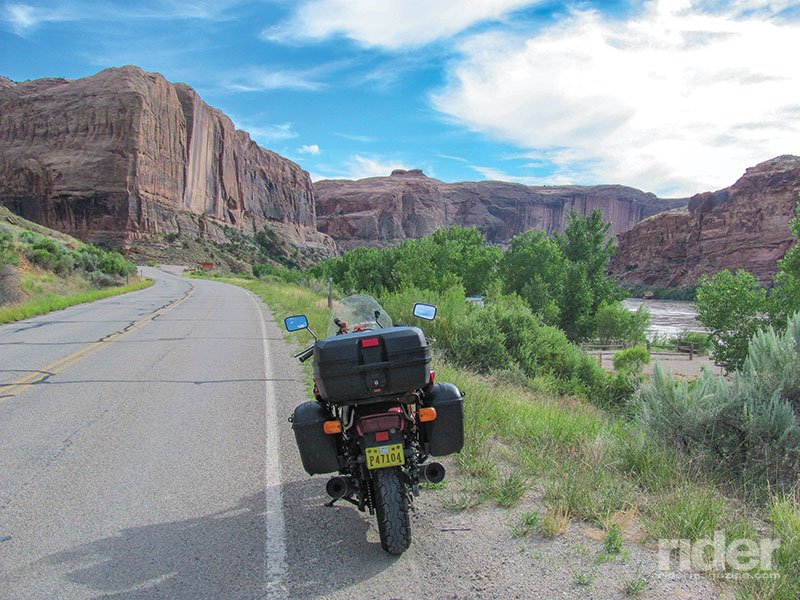
Just over the Utah state line, I veered off the Interstate to follow yet another backcountry byway. Utah State Route 128 consists of 44 miles of delightfully curvy asphalt, which follows the Colorado River where it emerges from remote Westwater Canyon and begins its descent into the red desert.
Around every curve, the road revealed more impossibly tall red cliffs and towers. The water level was so high that many tamarisk trees and beaches were underwater. Emerging from the scenic highway, I was immediately assaulted by the zoo called Moab. A far cry from the sleepy town described in Edward Abbey’s classic book Desert Solitaire, the Moab of today is packed with recreational users. Adventure travelers can choose from a dizzying assortment of options, from mountain biking to zip lining, hot air ballooning and skydiving. Almost nobody, it seemed, wanted to take the original Edward Abbey route, and just walk the red canyons in solitude.
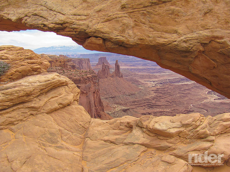
A short dirt road detour took me to an overlook of the Green River coursing through red rock in Canyonlands National Park. South of Moab, the Colorado River merges with the Green and disappears into Cataract Canyon. Meanwhile, U.S. Route 191 carried me to yet another scenic road. A turnoff at Bluff led beside the churning waters of the San Juan River. From where I had left it in Bloomfield, New Mexico, the river had picked up tons of silt and mud winding through the empty badlands of Four Corners, and now was rushing toward its rendezvous with the Colorado.
Years before, I had floated this section of the San Juan with a motley bunch of desert rat friends in kayaks and a paddleboat. It was a stunningly scenic journey past the textbook geologic wonders of synclines and anticlines and twisted red rock slot canyons. I paused on the bridge that spans the San Juan at the town of Mexican Hat to recall that long-ago wild ride on this desert river.

The San Juan and Colorado rivers join forces just west of Mexican Hat at Lake Powell. There the waters become a bathtub, which drowned Glen Canyon the same year I was born. Once released from the confines of Glen Canyon Dam, the giant Colorado River (now made up of waters from the San Juan, Animas, Los Pinos, Gunnison, Roaring Fork, Green and at least 20 other major rivers) had one more trick up its sleeve. As thunderstorm clouds gathered, I passed into Arizona and through iconic Monument Valley, the location of many cowboy movies. Then it was a quick jaunt through the Navajo reservation and up to the Desert View East Rim entrance to the Grand Canyon.
Looking down from 7,000 feet, I could see far below to the ribbon of reddish water called the Colorado. Its power had, over many eons, carved a mile-deep gorge in the plateau. I parked my bike and spent an hour sitting on the South Rim, staring out at the view. Dwarfed by the grandeur, I sat in the shade and listened to a canyon wren whistle down the sunset. This final triumph, the Grand Canyon, was a fitting conclusion to a ride along the principal watershed of the southern Rockies.


Excellent writing. Fantastic when riders combine their love of riding with another interest or two. Rivers and fires and riding. Thanks for the story.
looks like a fun ride, when in the beginning of the new year is the best time to do that trip? The last time we visited our daughter(we are from the land of the Chesapeake) we toured rt 191 in AZ. and how long should we give ourselves to enjoy this trip?
thanks
feel free to email me
The higher roads in Colorado are usually snow-free June through October. July and August are best. I did this trip in 7 days, including time to soak in Hot Sulphur Springs. KK
well, I guess this ride is not for me, only have the time Feb-March, in your stated desired months I sail about and work on sailboats in the Chesapeake.
A few years ago, I travelled on 191 from the south up to Alpine in AZ, beautiful…….guess I may do that one again….just so beautiful, thanks for writing
Happy New Year
thanks for writing, I sent a reply but it did not look to me as if it posted. So Snow is what the road bears!; guess I will not be travelling that one then, I only have Feb-March. If you get to the Chesapeake area, drop an email, sailing is our choice out here.
thanks
[…] http://ridermagazine.com/2016/11/09/follow-the-rivers-tracing-the-headwaters-of-the-colorado-river/ […]